Jan 5 Apr 12 Mar 13 Feb 15 May 16 Dec 16 Jun 18 Oct 19 Nov 20 Aug 24 Sep 26 Jul 33

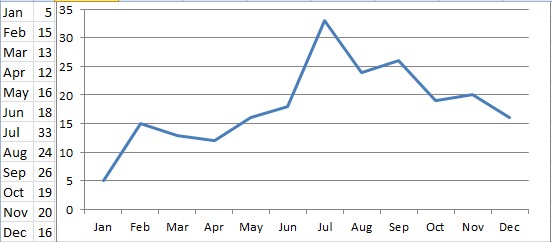
Fig.1 National days distribution on months of year
There is an uneven seasonal distribution of the national days of the countries in the world. More national days fall in the summer and early fall. Using data from Wikepedia, I summarize the months in which the countries observe their national days as follows (excluding special ones such as Israel, whose national day can vary between April 15 and May 15). The first column is month, and the second column is the count of countries whose national days fall in that month:
April 7
January 8
March 8
June 11
February 13
December 13
May 14
November 16
October 17
September 25
July 25
August 26
The Wikipedia data is not complete; it doesn't even have the day for Australia, among others. Using a more complete data set, from OfficeHolidays.com, I get a slightly different result:
Jan 5 Apr 12 Mar 13 Feb 15 May 16 Dec 16 Jun 18 Oct 19 Nov 20 Aug 24 Sep 26 Jul 33 |
 Fig.1 National days distribution on months of year |
Let's assume that the national day is when the country initially announced independence. As you can see, most countries announced their independence in July, August and September. With more than 200 data points, this cannot be completely accidental. There should be a good reason for it.
One hypothesis is that an independence war is more active in warm weather. In winter, the harsh cold weather slows down the progress, or rather, slows down the offence more than the defence, as the relatively inactive defending side is not impacted as much by external factors as the active attacking side is. There is a small surge in February. It may be due to the fact that at the end and beginning of a year, people are more or less in a holiday mood. After that, the independence activity resumes, with a burst of pent-up energy.
To test the hypothesis that low temperature in winter reduces the chance of independence, or rather, reduces the success rate of offense more than reduces the rate of defense, I come up with one idea to test it: Plot the national days according to the geographic latitude of the countries. If a country is in the southern hemisphere, their winter is actually summer in the north. If the hypothesis is correct, we should see a reverse trend for those countries: their independence days will largely concentrate in (northern) winter months. In addition, the countries near the equator will have less correlation than those in higher latitude, because the seasonal change at lower latitudes is not as obvious.
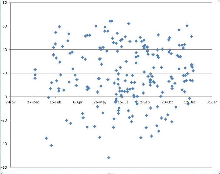
There is no "general" or "average" latitude of a country available. So I use the latitude of the capital of the country as an approximation, a method justified by the fact that a capital is usually one of the most contended cities in an independence war. The data thus combined is in Appendix. A plot of the data is Fig.2, where the y-aixs is the latitude for the capitals of the countries.

Fig.2 National days distribution on months and geographic latitude
As we can see, there is no clear correlation between latitude and independence days. Both northern and southern hemisphere countries have more independence days in the summer and early fall. There must be some factors that contribute to the seasonal distribution of national or independence days of the world countries. This research will continue and preliminary data and results will be given on this web page.
Appendix
NationalDayLatitudeData.txt
National Days are from OfficeHolidays, and Capital latitude data are from Wikipedia. The data in the datafile is tab-delimited and can be copied into Excel for analysis and plotting.
Forum discussion
July 2015
Contact me
To my Miscellaneous Page